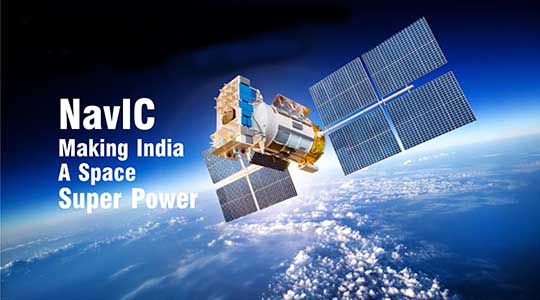
Only a few countries in the world have the technological capability to operate large-scale space missions and India is one of them. India has launched more than 80 spacecraft since its maiden satellite launch in 1975 by the Indian Space Research Organization (ISRO), currently operates INSAT and GSAT series communication satellites, earth observation satellites, and The Indian Regional Navigation Satellite System (IRNSS) series navigational satellites.

Dual-use satellites such as TES, Cartosat, Geo Aided GPS Augmented Navigation (GAGAN), and (IRNSS) serve both civilian and military applications, whereas India’s first dedicated defence satellite GSAT-7 serves the military.
India also executed the Mars Orbiter Mission (MOM) for $75m, spending approximately one-tenth of what NASA did on the MAVEN Mars mission.
The rise of NavIC
India has been launching satellites since 2008. It initially launched the Geo Aided GPS Augmented Navigation (GAGAN) system to help the civil aviation sector along with the up-gradation of airports. The results of the initiative in the civil aviation sector were very visible.
This was followed by the launch of satellites for the Indian Regional Navigation Satellite System (IRNSS) commencing in 2013. Both of these are integrated to provide Navigation with Indian Constellation (NAVIC or NavIC) since June 2019. This regional geo-positioning system has been designed in India by ISRO to provide accurate positioning in India and the Indian Ocean Region.
GPS Aided Geo Augmented Navigation (GAGAN)
For navigation requirements of the civil aviation sector, ISRO and the Airports Authority of India (AAI) have implemented the GPS Aided Geo Augmented Navigation – GAGAN as a satellite-based augmentation system (SBAS) for the Indian airspace. GAGAN system is inter-operable with other international SBAS systems like US WAAS, European EGNOS, Japanese MSAS, etc. GAGAN provides the additional accuracy, availability, and integrity necessary for various phases of flight, from en-route through approach for all qualified airports within the GAGAN service area.
Navigation with Indian Constellation (NavIC)
To meet the nation’s Positioning, Navigation, and Timing requirements, ISRO has established a navigation satellite system called (NavIC) which consists of both IRNSS and GAGAN Satellites.
A look at key players in Global Navigation Satellite Systems space
Global navigation satellite system (GNSS) is a general term describing any satellite constellation that provides Positioning, Navigation, and Timing (PNT) services on a global or regional basis.
GPS is the most prevalent GNSS, this system is owned by the U.S. government and operated by the United States Air Force (USAF) is the Global Positioning System (GPS). It is one of the several space-based navigation systems, which provides critical capabilities to military, civil, and commercial users across the globe.
GPS is freely available to companies, countries, and any individual with a GPS receiver. Owing to one of the numerous advantages that GPS offers, airlines, trucking companies, shipping companies, and vehicle owners use GPS systems to track and monitor the navigation route and location of flights, trucks, vessels, and cars in the shortest time possible. However, there are a few technological challenges associated with the use of GPS, therefore, some of the developed countries across the globe are exploring, testing, and deploying satellites to build their positioning capabilities. They include the following:
GLONASS (Globalnaya Navigazionnaya Sputnikovaya Sistema, or Global Navigation Satellite System) is a global GNSS owned and operated by the Russian Federation. The fully operational system consists of 24+ satellites.
Galileo is a global navigation satellite system (GNSS) that went live in 2016, created by the European Union through the European Space Agency (ESA), operated by the European Union Agency for the Space Programme (EUSPA) headquartered in Prague, Czech Republic. The full Galileo constellation will consist of 24 active satellites. In early December 2021, there were 22 launched satellites in usable condition.
The Indian Regional Navigation Satellite System (IRNSS) (renamed as NavIC) is an autonomous regional satellite navigation system that provides accurate real-time positioning and timing services. It covers India and the equatorial region. There are five more satellites that are scheduled to be launched in the coming months. Plans are also afoot to make its reach global rather than circumscribe it to India. A major forthcoming change is to add the L1 band into NavIC. The other major step would be to increase the “safety” of the signals.
BeiDou, or BDS, is a global GNSS owned and operated by the People’s Republic of China. BDS was formally commissioned in 2020. The operational system consists of 35 satellites. BDS was previously called Compass.
Quasi-Zenith Satellite System (QZSS) is a regional GNSS owned by the Government of Japan and operated by QZS System Service Inc. (QSS). QZSS complements GPS to improve coverage in East Asia and Oceania. Japan declared the official start of QZSS services in 2018 with 4 operational satellites and plans to expand the constellation to 7 satellites by 2023 for autonomous capability.
NavIC vs GPS: Which one is more accurate?
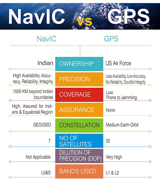
With seven satellites, NavIC is considered to be on par with any Global navigation satellite system (GNSS) including US-based GPS, Russia’s GLONASS, and Galileo developed by Europe.
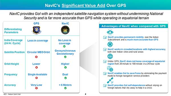
GPS or Global Positioning System tracks the entire globe and is maintained by the USA. The constellation requires 24 Satellites to be operational and has around 31 satellites in orbit. All of these are Geosynchronous Satellites, which is to say that they are not stationary in space concerning the revolving earth. GPS also uses a single frequency band and this makes calculations a bit more complex.
India has a series of 12 satellites for its NavIC.
Currently, 8 satellites from IRNSS and 3 satellites from GAGAN are providing navigational services in India.
NavIC satellites use dual frequency bands (L5-band and S-band), which is why the system is relatively more accurate than GPS (which uses a single band and makes compensation for errors due to signal deterioration by the atmosphere).
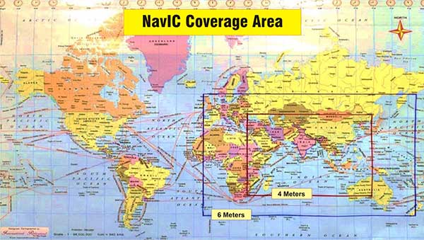
IRNSS is designed tIndiano provide accurate position information service to users in India and the equatorial region. The service area extends up to and the area enclosed by the rectangle from Latitude 30 deg South to 50 deg North, Longitude 30 deg East to 130 deg East.
IRNSS will provide two types of services, namely, Standard Positioning Service (SPS) which is provided to all the users, and Restricted Service (RS), which is an encrypted service provided only to authorized users.
The IRNSS System is expected to provide a position accuracy of better than 4 meters in the primary service area. Some applications of IRNSS include Terrestrial, Aerial, and Marine Navigation, Disaster Management, Vehicle tracking, and fleet management, Integration with mobile phones, Precise Timing, Mapping, and Geodetic data capture, Terrestrial navigation aid for hikers and travelers, Visual and voice navigation for drivers.
ISRO has also recently announced plans for five more satellites that are scheduled to be launched in the coming months. Another major forthcoming change is to add the L1 band into NavIC and increase the “safety” of the signals. This will make NavIC’s reach global.
In November 2020, The International Maritime Organisation (IMO) has recognized India’s NavIC as a component of the World-Wide Radio Navigation System (WWRNS) this recognition was awarded at the 102nd meeting of the Maritime Safety Committee of IMO (MSC-102).
NavIC – Government-Mandated Positioning System for Vehicles
ISRO’s satellite navigation system NavIC is set to become the backbone of a public vehicle tracking system in India since it offers flexibility to local law enforcement agencies to monitor vehicles unlike international systems like GPS. In April 2019, the Union Ministry of Road Transport and Highways made NavIC-based vehicle trackers mandatory for all commercial vehicles in the country following the Nirbhaya case verdict.
NavIC – Government-Mandated Positioning Systems for Drones
In August 2021 The Indian agency responsible for drone safety, DGCA, updated the drone rules for India. The rules promote the use of the Made in India technologies, designs and Indian regional navigation satellite system, namely, Navigation with Indian Constellation ( NavIC). The idea is to encourage, promote, and nurture innovation that leverages NavIC services and other allied indigenous geospatial offerings, and set India on a path toward domestic mapping and navigation capabilities. This would also open up opportunities for Indian drone developers to exploit potential markets outside India.
Indian Satellite Navigation Policy 2021
A new draft policy in India seeks to foster global use of its Indian NavIC satellite navigation system. The draft Indian Satellite Navigation Policy 2021 (SATNAV Policy 2021) is part of reforms of the Indian Space Research Organisation (ISRO)/Department of Space (DoS). DoS will utilize NavIC for all its global efforts to meet the demand for positioning, navigation, and timing in commercial, strategic, and societal applications. It aims to ensure the continuous availability of free-to-air navigation signals for civilian uses while providing secured navigation signals for strategic uses.
NavIC – Making India A Space Super Power
In the expanding commercial industry for space-based surveillance and communication, India has established itself as a “major player.” The Government has now proposed a restructuring of various sectors under the ‘Aatmanirbhar Bharat’ policy. One notable announcement has been the reformation of the Indian space industry. India’s private sector will be able to participate in India’s space journey through a new agency known as IN-SPACe. Satellite manufacturing services and launch services are projected to play a major role in boosting the Indian space economy by 2025. These endeavors are an effort to boost and honor national pride and propel India as a space super power by 2030. The nation has grown self-sufficient and is capable of creating its technology. India has established itself as a leader in the world for its successful low-cost missions thanks to its reduced costs and capacity to obtain locally based resources. All these efforts have cemented India’s position as a force to be reckoned with in a very elite group of space-faring nations.


